Monday, September 28, 2009

Prove Herewith-Sculpture Garden

"...the water was deep and very cold and we was drifted out of the regular crossing and we came near beign drounded the water came up to our arm pits poor mother was standing on the bank screaming as we got near the bank. I heard mother say ... some of you men help my poor girls."

Patience Loader: last crossing of the Platte River; 1856

Patience Loader was a member of the Edward Martin Handcart Company. Click on the link below and you can enter a name to see which company in the Mormon Pioneer Overland Travel Company (1847 - 1868) that the person you are interested in might have travelled with. Here is the link: http://www.lds.org/churchhistory/library/pioneercompanysearch/1,15773,3966-1,00.html

Thursday, September 24, 2009

Persistence - Sculpture Garden


"One day...[our son John]...started in the morning to walk with the aged and the sick, but we had not gone far on our journey when we found him lying on the roadside unable to go any further. I picked him up and put him on my back and drawed my cart as well as I could, but could not manage far so I put him in the cart with children and baggage, my failing husband, besides our regular load."

Elizabeth Sermon (1892 letter to her children)

Elizabeth Whitear Sermon, aged 37, was a member of the Martin handcart company which consisted of 575 souls, 145 handcarts and 8 wagons.

Anticipation - Sculpture Garden


"Beautiful day and a propitious wind brought us in sight of Yankee land which is the first land that we have seen since we left the sight of Ireland, and truly it was beautiful. ...It was truly sublime to us to gaze upon it. Our hearts were cheered to behold our destined port."


Samuel Openshaw, age 22 in 1856


Next to the Martins Cove Visitors Center, there is a sculpture garden. Next to each sculpture is a quote that inspired the creation of the sculpture.

Sunday, September 20, 2009

Sweetwater Crossing

Above: The carved stone honors the young men who on November 4, 1856 carried those too tired or cold across the Sweetwater River.

The Sweetwater crossing is one of the spiritual activities that takes place on Trek. When the rescuers arrived to bring the suffering members of the handcart companies to safety, they determined that they should move them from the intense cold and exposure of Fort Seminoe to the more sheltered place now named Martins Cove. When they arrived at the river, many of the company, remembering the earlier crossing of the freezing, ice filled North Platte River simply sat down, too tired and fearful to cross. Many who had crossed the North Platte had fallen ill and some had died from the wet and cold.

Young men from the rescue party including George W. Grant, C.A. Huntington, David P. Kimball and Stephen W. Taylor began to carry the women and children across the freezing river. They would make the journey may times before all had crossed to the other side.

Above, a view from the middle of the bridge over the Sweetwater River.

The place where trekkers cross is called the "silent" crossing (at the top of the image). At this place, Trekkers re-enact the crossing with the young men carrying the young women across the river. You may also pull your handcart across the river.

Our group is crossing the Sweetwater at the silent crossing. There is a great opportunity to strengthen your testimony and feel the spirit by considering the sacrifice and suffering experienced by the pioneers and the service performed by their rescuers.

Above: This is the view from the other side of the "Silent" crossing on the Sweetwater River. The river is approximately knee deep and provides a cool refresher from the heat of the day.

Saturday, September 19, 2009

Martins Cove Leadership Training

Approximately 360 miles by car, this is the site that greets you when you make the trip from Salt Lake City, Utah to Martins Cove in Wyoming.

This Friday and Saturday, a number of us got to travel up to the Trek site for an orientation. During orientation, the full-time missionary couples immerse you in the background that led to the creation of the site.

You begin in an orientation session (ours was packed) where there is a program including a multimedia presentation. The goal is to provide ideas on what your group will experience during trek and to inform you about the resources available.

Be prepared, they are really serious. After the orientation, we were divided into groups, given a handcart and off we went. They told us it would be a "breezy" 6 mile walk (it is really 7 miles, I took a GPS).

I met up with a great group of guys from Bountiful (North Salt Lake) who are bringing a group similar in size (350 individuals) next summer. As we trekked from place to place (more in a later post) we talked about our own treks and how to prepare our leadership and youth to be ready for this "once in a lifetime" opportunity. More than telling us, they demonstrated with personal knowledge steeped in the history of the site. There was even role playing where some of the missionaries assumed the identity of the original settlers.


This view is from a rest area where you prepare to journey on a 2.3 mile loop into Martins Cove. Right in the center (very small) is a group of trees that marks the vistors center and the entrance shown in the top photo. This spot is about 1.3 miles from the place designated as the "start" of trek.

Wednesday, September 16, 2009

Patience Loader


Patience Loader was a member of the Martin Handcart Company. In an article from Sherman L. Fleek that appeared in the June 1997 issue of Wild West, he writes:

Teenager Patience Loader watched the large chunks of ice float down the freezing North Platte River in the fall of 1856. There was no other choice; James Martin, captain of their company of Mormon emigrants, said that they had to ford the river at Last Crossing. The cold October wind made unbearable the task of pushing and dragging the hand-drawn carts across. Patience, her sister and mother had no change of clothes, and there would be no time to stop and dry their drenched and freezing garments until they stopped for the night, many more miles and hours away. Exhibiting the great virtue her name symbolized, Patience and her family entered the icy flow. Later, she recorded her experience:

‘The water was deep and very cold and we drifted out of the regular crossing and we came near beign drounded the water came to our arm pits poor Mother was standing on the bank screaming as we got near the bank I heard her say for God Sake some of you men help My poor girls…Several of the brethren came down the bank of the river and pulled our cart up for us. Mother was there to meet us her clothing was dry but ours was wett and cold and verey soon frozen Mother took of one of her under skirts and put it on one of us and her apron for another to Keep the wett cloth from us for we had to travle several miles before we could camp.’

Freezing and nearly drowned as she was, Patience nevertheless was saddened by the sight of a less fortunate handcart member:

‘When we was in the middle of the river I saw a poor brother carreying his child on his back he fell down in the water I never Knew if he drowned or not I fealt sorrey that we could not help him but we had all we could do to save ourselves
from drownding….’

While Mr. Fleek refers to Patience in the article as a "teenager", her Death Certificate indicates that she would have been 29 according to information provided by Sherry M. Smith in a memorial.
Patience has many other stories of trials she experienced while on the trek that we'll provide in future posts.

Thursday, September 10, 2009

1855 Map

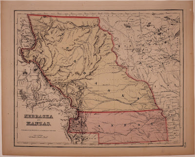
The map above was published in New York in 1855 the year before the Willie and Martin Companies began their long trek from England. Since the Martin Company sailed into the port of New York, it is likely that they had a map just like this one to follow as they embarked on their trek. I can imagine the days and nights spent studying the map, wondering "how much further" and what lay ahead.

While the map is not very detailed (click on it to see it larger), it does show points on which the pioneers could get their bearings. Places like "Court House Rock", "Chimney Rock", "Scotts Bluff" and the exotic "Fort Laramie" excite the imagination and give hope to weary travelers.

If you look on the right hand side up approximately one third from the bottom, you'll see Omaha City (Florence) right across from Council Bluffs. Follow the Nebraska or Platte River from just below Omaha City (right to left) continuing up the North Fork of Platte R. and you'll see the approximate route taken by the pioneers.

Just past Ft. Laramie, you'll see "Devils Gate" and the Sweetwater River that you follow to Ft. Bridger and on into the Salt Lake Valley. While there are lots of other maps, I find this one quaint because of the spelling of "Kanzas"

If you'd like to follow a "day by day" account of the journey taken from actual trek journals, you can click on http://handcart.byu.edu/ This site was set up in 2006 for the 150 year celebration of the Trek.

Wednesday, September 9, 2009

Destination Salt Lake City

Above is an imaginary view of Salt Lake City from about 1850

From 1855 and 1864, more than 400 missionaries left Salt Lake City for the mission field. In 1950, the population of the valley was approximately 6,000. By 1890, the population approached 45,000 mostly due to emigration that was a result of missionary work.

In an effort to encourage and enable emigration, the church established the Perpetual Emigrating Fund Company in 1849. The fund was considered a debt to be repaid with cash, labor or in-kind. More than 30,000 emigrants used the fund and many paid it back. Those who did not repay were considered part of the "worthy poor" and their debt was forgiven during the year of Jubilee.